Entire area
A frontal boundary will approach the region and then stall out. As the front stalls out, a strong wave of low pressure will move northeast along the boundary and bring periods of heavy rainfall to the region. The heaviest rainfall will fall generally on either side of the Ohio River from Wednesday night through Thursday night. The National Weather Service in Louisville has issued a
* Flood Watch for portions of Indiana and Kentucky
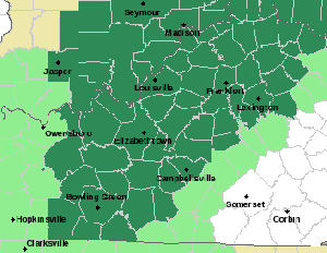
* From Wednesday evening through Friday morning
* Moderate to heavy rainfall is expected Wednesday night through late Thursday night. Total rainfall amounts in the watch area are expected to average between 2 to 4 inches with locally higher amounts possible.
* The rainfall will likely lead to nuisance flooding issues Wednesday night into Thursday with quick rises on area creeks and streams Wednesday night and possibly continuing through the end of the week.
A Flood Watch means there is a potential for flooding based on current forecasts. You should monitor later forecasts and be alert for possible Flood Warnings. Those living in areas prone to flooding should be prepared to take action should flooding develop.
 AG Rokita Sues IHSAA to Eliminate Race Quota from High School Sports Leadership
 KSP Charges Gallatin County Man with Child Sexual Exploitation Offenses
 Kentucky Governor and First Lady Recognize Kentucky’s Leading Role in Fight Against Childhood Cancer